
 Web Content Display
Straż leśna
 Strażnicy leśni w pracy (foto K.Polus)
 Teren Nadleśnictwa jest monitorowany za pomocą fotokamer.
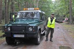
 Straż leśna kontroluje samochody wjeżdżające do lasu (foto K.Polus)
Do zwalczania szkodnictwa Leśnego została powołana Dekretem Prezydenta Rzeczpospolitej z dnia 30 września 1936 r. Straż Leśna, która z pewnymi zmianami funkcjonuje do dziś.
W Nadleśnictwie Wymiarki posterunek Straży Leśnej jest dwuosobowy, a straznicy kontrolują lasy Nadleśnictwa korzystając ze służbowego samochodu terenowego marki Landrover. Dodatkowo w celu ochrony lasów przed szkodnictwem na terenach leśnych Nadleśnictwa Wymiarki prowadzony jest monitoring przy użyciu urządzeń rejestrujących.
Do podstawowych obowiązków Straży Leśnej należy ochrona mienia wspólnego, jakim są Lasy Państwowe zgodnie z ustawą o lasach z dnia 28 września 1991 r. (z późn. zmianami).
Asset Publisher


Asset Publisher
LOCATION
LOCATION
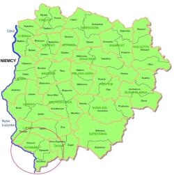 Mapa RDLP i lokalizacja N-ctwa (Autor K.Polus)
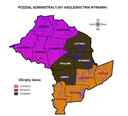 Podział administracyjny N-ctwa (Autor K.Polus)
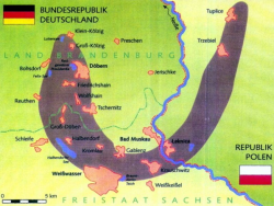 Największa na Ziemi morena czołowa. Źródło: Informator Regionalnej Dyrekcji LP w Ziel. Górze
 Żródło:www.borydolnoslaskie.org/
 fot. Mariusz Grondys
 fot. Mariusz Grondys
The Wymiarki Forest District is one of the twenty forest districts of the Regional Directorate of State Forests in Zielona Góra It is located in the South-West part of Lubuskie Province.
The western border of the Forest District is situated along the Polish border in line with the twenty-eight-kilometre-long stretch of the Lusatian Neisse River (Nysa Łużycka). The lands of the Forest District are located between 14º47'03" and 15º11'12" East longitude, and between 51º21'47" and 51º35'50" North latitude.
The territorial scope of the Wymiarki Forest District activity is 33187 ha. The Forest District manages lands located in two districts and seven communes.
Żary District, with the area of 22,836 ha (in communes such as: Trzebiel 2,210 ha, Lipinki Łużyckie 1,031 ha, Przewóz 17,832 ha, Żary 1,763 ha).
Żagań District, with the area of 10,351 ha (in communes such as: Iłowa 3,295 ha, Wymiarki 4,659 ha and the townof Gozdnica2,397 ha).